Avalanche danger bulletin of Principat d'Andorra
Prepared on 25/04/2024 16:00, valid until 26/04/2024Next update 26/04/2024 at 16:00
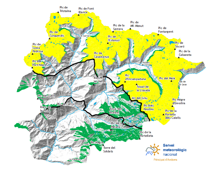


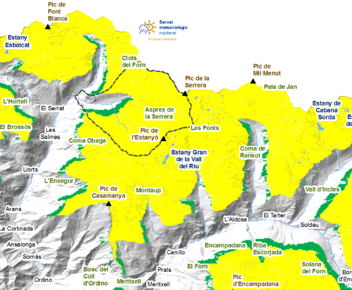
Off-piste snow cover thicknesses
| North zone | Snow thickness | |||
| Snowpack | 1500m | 2000m | 2500m | |
| N | 2000 m | 0 cm | 40 cm | 150 cm |
| S | 2400 m | 0 cm | 0 cm | 40 cm |
| Center area | Snow thickness | |||
| Snowpack | 1500m | 2000m | 2500m | |
| N | 2000 m | 0 cm | 40 cm | 100 cm |
| S | 2700 m | 0 cm | 0 cm | 30 cm |
| South zone | Snow thickness | |||
| Snowpack | 1500m | 2000m | 2500m | |
| N | 2000 m | 0 cm | 20 cm | 80 cm |
| S | 2700 m | 0 cm | 0 cm | 10 cm |
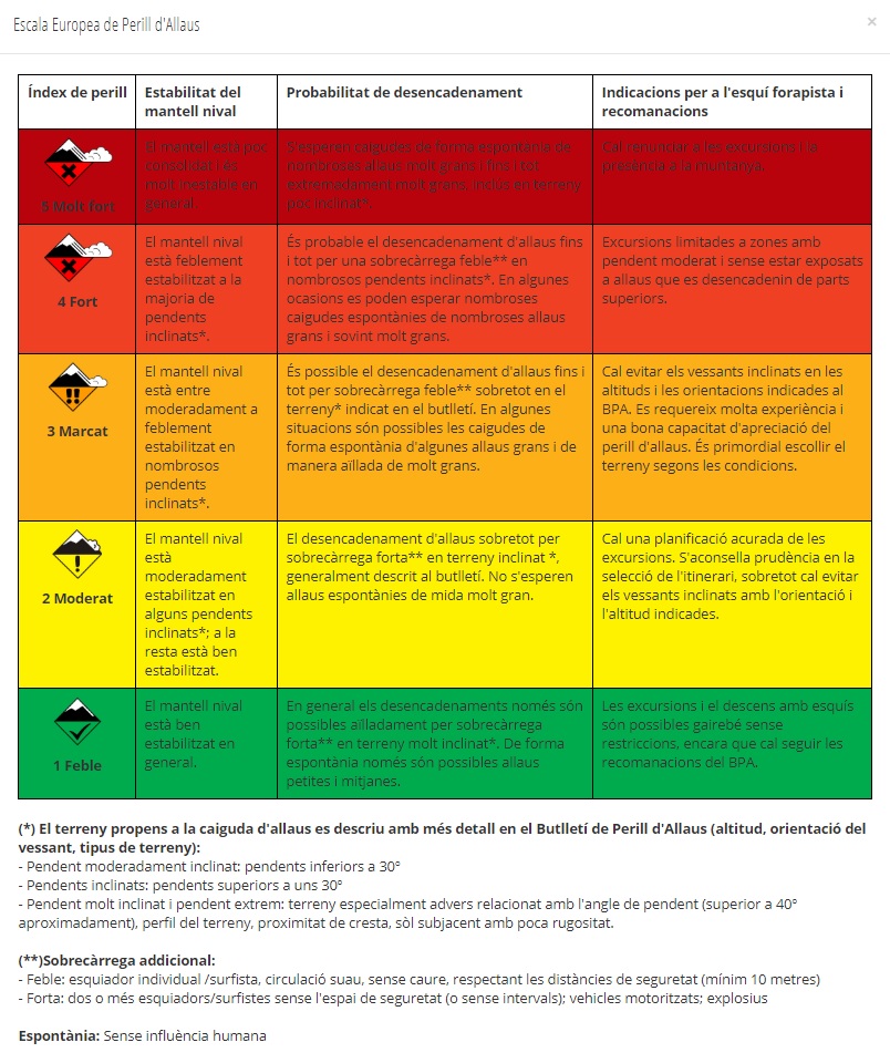
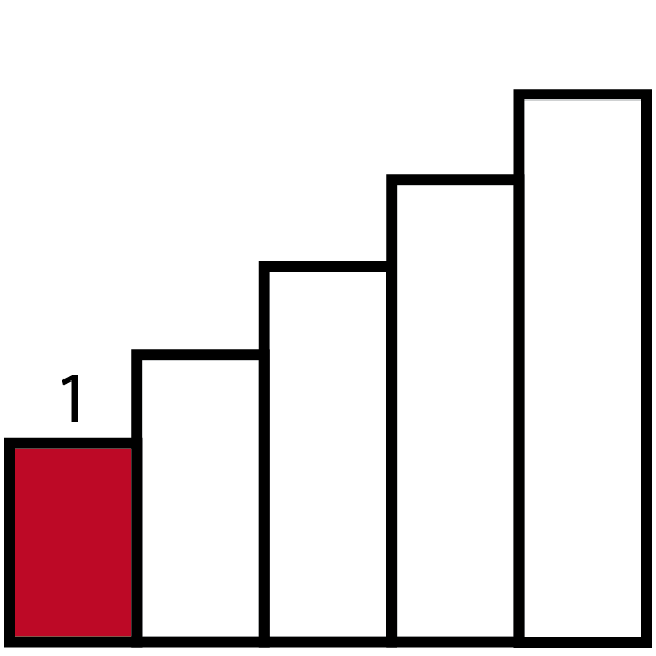
Snowpack stability
Weak layers exist in the top section of the snowpack in particular on steep northeast, southeast and southwest facing slopes. Avalanches can be released , even by small loads in isolated cases and reach medium size. As a consequence of solar radiation small and, in isolated cases, medium-sized moist snow slides and avalanches are to be expected. This applies in particular at the base of rock walls.Snow quality
In particular in the north 30 to 40 cm of snow, and up to 60 cm in some localities, has fallen since Tuesday above approximately 2100 m. Snow depths vary greatly , depending on the infuence of the wind. The avalanche prone locations are covered with new snow and are difficult to recognise.Detailed information for protected areas
Sorteny
In the lower parts of the valley there is little snow and it is not possible to ski. The continuous snow will be found above the level of the forest and is where the most recent snow has accumulated. On the southern slopes, although the appearance may be white at altitude, skiing is not recommended, as there is not enough thickness to insulate the floor. The new snow is quite dense and can sometimes make it difficult to descend, when it compacts and two sunny days follow, there will be better conditions.
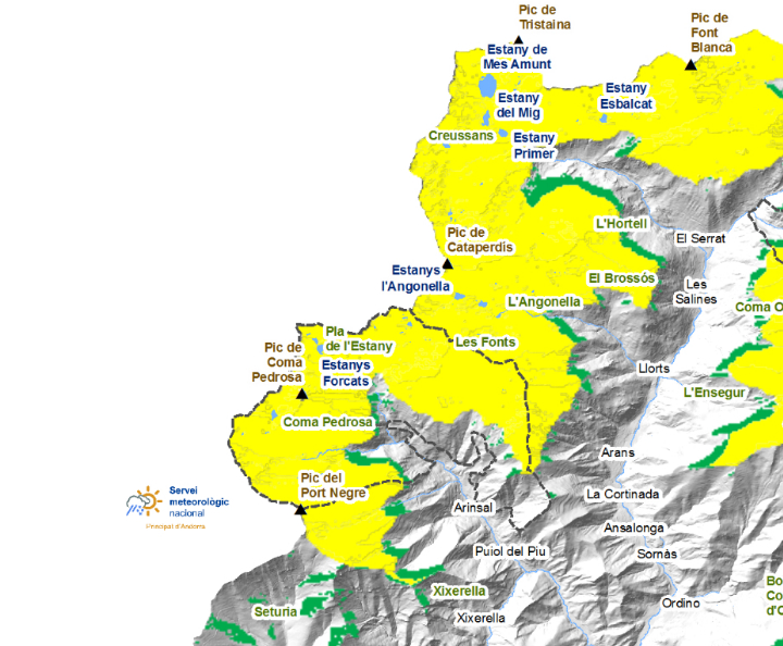
Comapedrosa
Stability and traffic conditions are similar to Sorteny. We can't rely on the snow to hold our weight on the ice bridges that cross the rivers or the ice on the ponds. It is expected that during the next few days significant thicknesses will accumulate at high altitudes. We will have to wait for the snow cover to compact before going out to ski it.
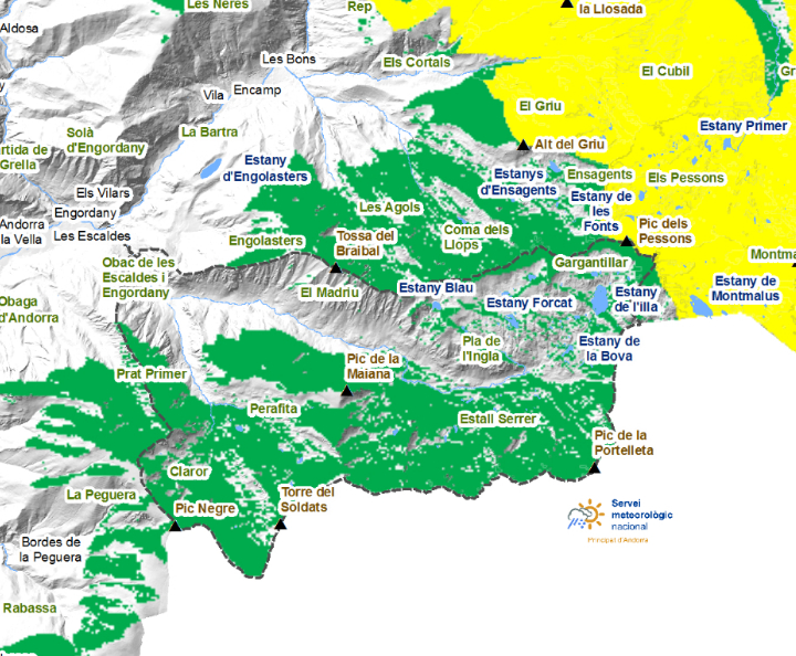
Madriu-Perafita-Claror
At higher elevations there are significant accumulations, but the snow has retreated quickly to the valley floors and below the forest line. The ski resorts make the approaches easier, but with some interruptions. To go up to Montmalús, for example, it is better to do the lower part on the black \frog\ track. The snow remains cold, especially on the northern slopes and at altitude, but the achievement of days with precipitation makes us advise to wait to make new ski trips.
Thick snow in recent days (last 24 hours measured at 06:00 UTC)
| 22/04/2024 | 23/04/2024 | 24/04/2024 | 25/04/2024 | |
|---|---|---|---|---|
| Aixàs | 0 cm | 0 cm | 0 cm | 0 cm |
| Engolasters - FEDA | 0 cm | 0 cm | 0 cm | 0 cm |
| Ransol - FEDA | 1 cm | 0 cm | 0 cm | 0 cm |
| Fontverd | 0 cm | 0 cm | 0 cm | 0 cm |
| Setúria | 2 cm | 4 cm | 0 cm | 0 cm |
| Bony de les Neres | 0 cm | 6 cm | 0 cm | 0 cm |
| Grau Roig - FEDA | 0 cm | 0 cm | 0 cm | 0 cm |
| Caborreu | 0 cm | 0 cm | 0 cm | 0 cm |
| Sorteny | 14 cm | 9 cm | 0 cm | 85 cm |
| Coll Pa | 10 cm | 0 cm | 0 cm | 1 cm |
| Perafita | 4 cm | 0 cm | 0 cm | 0 cm |
| Tossa Espiolets | 0 cm | 4 cm | 0 cm | 3 cm |
| La Solana | 10 cm | 6 cm | 0 cm | 6 cm |
| Les Fonts d'Arinsal | 0 cm | 10 cm | 0 cm | 0 cm |
 5 Very strong
  4 Strong
  3 Marcat
  2 Moderate
  1 Weak