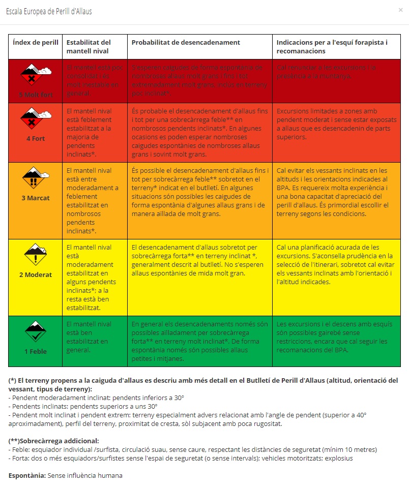
| Hazard Index | Snow Cover Stability | Trigger probability | Off-piste skiing directions and recommendations |
 5 Very strong 5 Very strong | The mantle is poorly consolidated and very unstable in general. | Numerous very large and even extremely very large avalanches are expected to fall spontaneously, even on slightly sloping terrain *. | Excursions and presence in the mountains must be abandoned. < / td> |
 4 Strong 4 Strong | The snow cover is weakly stabilized on most sloping slopes *. < / td> | Avalanche triggering is likely even due to weak overload ** on numerous sloping slopes *. Sometimes spontaneous falls from numerous large and often very large avalanches can be expected. | Excursions limited to areas with a moderate slope and without being exposed to avalanches that are triggered from upper parts. | < / tr>
 3 Marcat 3 Marcat | The snow cover is between moderately to weakly stabilized on numerous sloping slopes *. | Avalanche triggering is possible even due to weak overload ** especially in the terrain * indicated in the bulletin . In some situations it is possible to fall spontaneously from some large avalanches and in isolation from very large ones. | Sloping slopes at altitudes and orientations indicated in the BPA should be avoided. It requires a lot of experience and a good ability to appreciate the danger of avalanches. It is essential to choose the terrain according to the conditions. |
 2 Moderate 2 Moderate | The snow cover is moderately stabilized on some sloping slopes *; in the rest it is well stabilized. | The triggering of avalanches mainly by strong overload ** on sloping terrain *, usually described in the bulletin. Spontaneous avalanches of very large size are not expected. | Careful planning of excursions is required. Caution is advised in the selection of the route, especially it is necessary to avoid inclined slopes with the indicated orientation and altitude. |
 1 Weak 1 Weak | The snow cover is generally well stabilized. | In general, triggers are only possible in isolation due to strong overload ** on very sloping terrain *. Only small and medium avalanches are possible spontaneously. | Excursions and downhill skiing are possible almost without restrictions, although BPA recommendations must be followed. |
(*) Avalanche-prone terrain is described in more detail in the Avalanche Hazard Bulletin (altitude, slope orientation, terrain type): - Moderately sloping slope: slopes less than 30º
- Inclined slopes: slopes greater than about 30º
- Very steep slope and extreme slope: especially adverse terrain related to the slope angle (greater than approximately 40º ), terrain profile, ridge proximity, underlying ground with little roughness.
(**) Additional overload: - Weak: individual skier / surfer, smooth circulation, without falling, respecting safety distances (minimum 10 meters)
- Strong: two or more skiers / surfers without l 'security space (or no intervals); motor vehicles; explosives
Spontaneous: No human influence